Route: Melbourne – Diamond Creek – Seymour – Rusworth – Echuca – Barham – Murrabit – Swan Hill
Day 50 & 51: 29 & 30 March 2019
Melbourne
On arrival in Melbourne, I saw another bicycle on board the Spirit Of Tasmania.
Bianca, living literally a stone’s throw away from the ferry landing, had just cycled a tour around Tasmania as well.
We went for a very delicious breakfast together before I went off, getting supplies in the Coles supermarket.
On my ride into the city centre, I was stopped by an older Asian man on an old bike. He introduced himself as ‘Master Tai’, A 76 year old Chinese Man. He had plenty of houses in Melbourne, told me about how he had had a flourishing business in China, but gave everything to his ex-wife.
He came back to Australia, starting from scratch, and in no time had millions of dollars again.
“I like what you do, I can give you millions”
“I can even turn that stone into gold’, he told me.
“Turn my bike into gold”, I said to him, but he couldn’t live up to his claims.
“Next time I see you, I turn you into a millionaire”, he said again.
I thanked him for his kindness and rode on into town, where I wanted to visit some of the outdoor stores before noon time, when I had to be down at the Princess Bridge to meet up with Paul,a cyclist originally from Adelaide, who makes regularly long trips in Europe and has his own website, https://www.ebiketraveller.site.
The plan was to stay one day only, but bad weather on Saturday decided otherwise.

On Saturday, a French couple, Philippe and Marie arrived. They had stayed with Paul before, on their arrival in Australia.
It’s a fine neighborhood here, with some trendy café’s and best of all, a big Asian community, mainly Vietnamese it seems, but also Thai and Chinese, with their own shops and restaurants. Yup, a neighborhood I could live.
Day 52: 31 March 2019
From Melbourne to Wild Dog Creek
63,68 km km (Total so far: 1935,84 km) – Altitude climbed: 827 m
Weather: Cloudy, rain
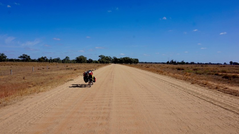
Also today the weather was still cloudy and some rain was predicted in the afternoon. I was so anxious to start my long trip, crossing the Australian continent south to north, that I couldn’t wait another day.
Paul joined me for the first kilometers.
I had made my route along the Yarra River Trail. Not the shortest route to leave town, but it’s car free and mostly along the green river banks so you’re not even realizing you are leaving such a big town.
All locals along the trail were very outgoing and every time I stopped they approached me enquiring where I was going, etc…
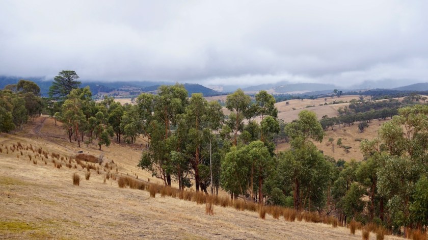
After the Yarra Trail, I took the Diamond Creek Trail. From here, the road starts to climb. Not too serious, but you’ll have to work a bit already.
The Great Dividing Range was covered in clouds and it started raining, so that has to wait another day. Barely 17 degrees today.


Day 53: 1 April 2019
From Wild Dog Creek to King Parrot Creek
49,56 km (Total so far: 1985,40 km) – Altitude climbed: 780 m
Weather: Cloudy, sunny, light tail wind
Steep.
Steep !!
I managed again to chose the steepest way over the range, I think.
That dirt road through the King Lake National Park. I could cycle it, with great efforts, when the gradients were 14 or 15%. Most of the time however, it was steeper and I had to push. Sometimes 18%, after that, I pushed too slow to register the inclination.
Interestingly, I passed some memorials for the big forest fires that raged through this region on 7 February 2009 and killed 14 people in St. Andrews alone, as much as 173 in the whole state of Victoria. The event is now known as Black Saturday.
That day, temperatures were 45,7 °C and winds of 150 km/hr started new fires in instants 20 kilometer away from the previous spot.
The Black Saturday Fires destroyed areas extending some 100 km from west to east.
Today, temperatures were as low as 14 degrees only.
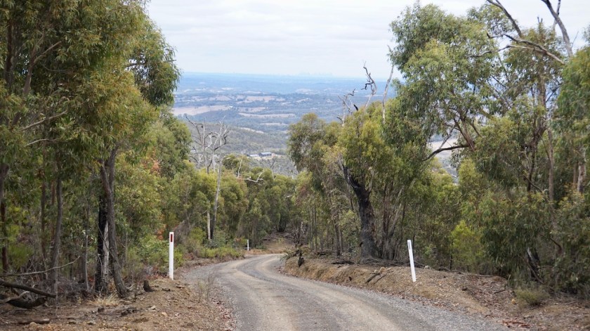

At the junction with the paved Whittlesea-Kinglake Road C724, I reached the highest point at 648 meter.
Not impressive, you would think.
Well, try and do it. It was very hard. Luckily, once at the top, finally the sun came out.
Melbourne under a thick layer of clouds at one side, the hinterland bathing in the sun.
There is some sort of unmaintained bike path along the road which keeps me nicely separated from the traffic.
The downhill was very smooth, except from one steeper part, so should be easier coming from the other side.
Today I cycled from ‘Wild Dog Creek’ to ‘King Parrot Creek’.
Sounds nice he 🙂
By the way, yesterday I saw King Parrots. What exceptional beautiful birds.
I also saw many Red Crimson Rosella’s and Eastern Rosella’s.
The Sulphur-crested Cockatoo’s are everywhere in flocks of 20 or 30 birds making lots of noise.
Fantastic.
Lost my tripod today 😦

Day 54: 2 April 2019
From King Parrot Creek to Northwood Hill
66,62 km (Total so far: 2052,02 km) – Altitude climbed: 441 m
Weather: Sunny, moderate & strong tail & side wind
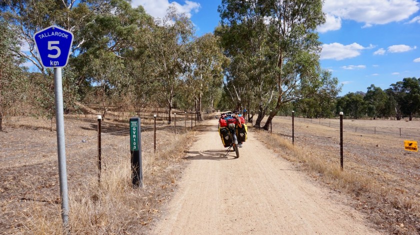
Along the King Parrot Creek Road, I cycled towards the Great Victorian Rail Trail, which I left again a bit before its end (or beginning) to cycle via the School House Lane towards Seymour.
There is a huge Vietnam War Memorial at this place. Or American War Memorial, as it would be called by the Vietnamese people.
Cycled out of town, then took Northwood Road. All land is fenced off, found a reasonable place in a bend in the road where the fences were a bit further off.
did I see a Whistling Kite today ?
Not sure, so not ticking it off.


Day 55: 3 April 2019
From Northwood Hill to 5 km bf Rushworth
59,87 km (Total so far: 2111,89 km) – Altitude climbed: 396 m
Weather: Sunny, light head and side wind
Thanks to careful planning in the months before I left to Australia, I ended up riding a few interesting gravel roads like the Weir Road and the tracks through Whroo Nature Consevation Reserve. I ended up in Rushworth, a little town established in 1853 during the gold rush.
One of the nicest little towns I came through so far.
Well maintained old buildings, all friendly people. I cycled out of town with Damian, a fellow local cyclist.


Day 56: 4 April 2019
From 5 km bf Rushworth to Yambuna
60,81 km (Total so far: 2172,70 km) – Altitude climbed: 90 m
Weather: Cloudy, sunny, moderate head wind
Flies !!
I was warned about them, and read about them in several blogs from other cyclists and today, as I crossed the C345 (Bendigo – Murchison Road) , going north from Rushworth, they were suddenly there. Not a few. Hundreds !
They sit on your back, on your bags, on your wet laundry, circle around you, try to get into your ears, your nose.
The legionair cap I bought in Melbourne, combined with a bandana and good sunglasses that sit close on your face help a lot, but it is super annoying when you stop, or when you want to eat.
They are persistent.
They don’t bite.
I continued riding straight north.
Flat lands here, irrigation channels, cattle, all land fenced off, just like the previous days.
Uninspiring country, but a nice change after all the climbing on Tasmania.
I pitch the tent about six kilometer north of the Murray Valley Highway in the Allan Corry Roadside Reserve.
Day 57: 5 April 2019
From Yambuna to after Moama
42,92 km (Total so far: 2215,62 km) – Altitude climbed: 77 m
Weather: Sunny, strong head wind
On the fifth day of April, around noon time, I reach the borders of the Murray River …
A strong head wind all day, no matter in which direction I turn the handle bars. You have those days.
But it’s a good day.
I should have ridden a few kilometers longer yesterday, because I see some really good camping spots along the Goulburn River, just before its confluence with the Murray River.
I leave the bumpy Glanville Road for the Bangerang Road, staying as close to the river as possible.
In Echuca I find a new Gorilla Pod in the local camera shop. It’s even cheaper as in Europe.
Echuca is a nice place, some older buildings, a McDonalds I visit and a long visit to the library to recharge all the devices.
From Echuca, I cross the Murray River and enter my third Australian state, New South Wales.
I visited the two smallest ones, Tasmania and Victoria already. New South Wales is the most populous, but also the third smallest of the seven. I know this statement is not entirely correct, because you have states, and territories, and there’s also the Australian Capital Territory and the Jervis Bay Territory, but these are so small, and to keep things simple, I reckon with seven states, because that’s how it looks at the map.


The Murray River is hundred meter asl here, still more than a thousand kilometer from its mouth.
That will be some slow moving stream. The Murray is also Australia’s longest river and will be my companion for the coming weeks.
Ten kilometer west of Moama is a forest with mtb trails along the Murray and plenty of goods places to pitch a tent.
Day 58: 6 April 2019
From 10 km passed Moama to Koondrook State Forest
60n18 km (Total so far: 2275,80 km) – Altitude climbed: 60 m
Weather: Sunny, moderate head wind / no wind in the forest
What a brilliant ride today.
I left my pitch along the Murray quite late, too occupied with Thai Airways giving me a hard time returning money of my cancelled tickets, and also trying to decide which tent I should order.

The first ten kilometer of the day along the asphalted Perricoota Road are nothing special, but once I take a left turn into the Perricoota Forest Road, the fun begins.
Asphalt disappears, washboard for a little while, but then a good hard packed sand road through open farm land.
Once I enter Perricoota State Forest, all fences disappear and it’s a very beautiful ride through the forest. The Murray River is very winding here and always appears and disappears.
Camping is possible everywhere.

I stop along one of the bends in the river to wash out some clothes and have a swim.
The Perricoota Forest becomes the Koondrook State Forest where, after 2270 km into my ride here, I have my first flat tyre.
I pump it a few times until I find a good spot for the night, and patch the tube after pitching the tent.
Saw two groups of four Emu’s today, running alongside me, crossing my path, joinced by kangaroos. It feels like cycling through Jurrasic Park.
Great day.
Day 59: 7 April 2019
From Koondrook State Forest to Campbells Island State Forest
51,18 km (Total so far: 2326,98 km) – Altitude climbed: 28 m
Weather: Sun, moderate head wind
The joy of cycling along the Murray continues, here on the New South Wales Side.
Before reaching the asphalt and riding into the small town of Barham, I saw one car.
When you see more kangaroos than cars, life is good.

Two supermarkets in Barham, a ‘Foodworks’ and an ‘Iga’.
I chose the Foodworks, because I’ve never entered one. There’s also a Thai restaurant in town (Happy Elephant Thai – it was closed on a Sunday afternoon) and in the small park I found an electrical outlet to charge the phone and laptop. Two poles of my tent are starting to break. I repaired them but that’s not gonna last, and I don’t want to end up in the desert with a collapsed tent, so I ordered a new one.
I was at the point of ordering a Hilleberg Rogen. The tents are so good and so beautiful, but of course you also pay for what you get.
So I changed my mind, and ordered a cheaper Marmot tent, hoping that will last for the remainder of the Australia trip, and save a new Hilleberg for later, when it can be used in the conditions it was built for.
The Marmot has a full free standing mesh inner tent, which will be cool in the desert, and allow me to watch the stars (or be blinded by the moon when I try to sleep).
Leaving Barham, I stay on the NSW side of the river and after two kilometer or so, I am back on the gravel, entering the Campbells Island state Forest.
Until tomorrow morning, when I write this, I saw zero cars.
A new spot right beside the Little Murray River (the river splits in two for a while, a bit after Barham.)
After Barham I entered the Fruit Exclusion Zone, or Pest Free Zone, I don’t know exactly, but I didn’t see any checkpoint for this.
Day 60: 8 april 2019
From Campbells Island State Forest to 12 km before Swan Hill
62,63 km (Total so far: 2389,61 km) – Altitude climbed: 54 m
Weather: Sun, strong head wind
A battle against the wind, that’s what it was today. All was fine as long as I was on the bumpy gravel road at the New South Wales side of the river but after hitting the asphalt and crossing the Murray it was a full on strong wind in the face.
I filled up the water bottles and bladder in Murrabit, a neat little community on the Victoria side which has made a real effort in putting panels everywhere explaining the historic relevance of the place and its railway.
From Murrabit, I was mostly on asphalt, but still my speed often wasn’t above 10 or 11 km/hr because of this wind.

But hardly any traffic. I was grateful for the good preparation I’ve put in this whole route.
Part of this reparation, I’ve put waypoints in my gps with possible interesting spots to have a look at.
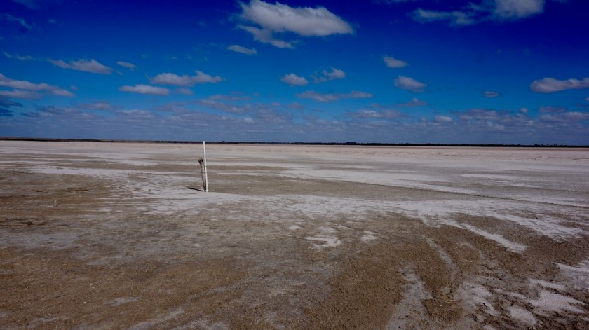
One of these was Lake Tutchewop. I had imagined to see a lake, but what I got was a South-American style dry salt lake. Very surprised and very happy I battled this extra kilometer against the wind to have a look at it.
Highlight of the day.


Or was that this huge Australian Pelican that took off ride beside me when I cycled along an irrigation channel.
This bird was huge and it took him so much effort, flying in big circles, to gain altitude as if it were a large Boeing taking off.
What a magnificent animal.
It has the longest bill of any living bird and has a wing span of 2,3 to 2,6 meter. The record bill size is 50 centimeter.
At least as impressive to see as the Andean Condor.
I camped on Pental Island, a piece of land between the Murray and the Little Murray Rivers, about ten kilometer before Swan Hill, not wanting to enter the ‘big town’ tonight.
More about that, enter re-entering New South Wales where I visit Mungo National Park in the next post.
