Route: Freycinet National Park – Avoca – Evandale – Deloraine – Mount Roland – Devonport
Day 38: 17 March 2019
From Passed Apsley River to few km before Coles Bay
45,87 km (Total so far: 1471,45 km) – Altitude climbed: 745 m
Weather: Sunny, strong head / side / tail wind
Again, what a day !
The highlights keep following up.
I was lucky with the weather again. A bit a cloudy morning but the afternoon and evening were brilliant.
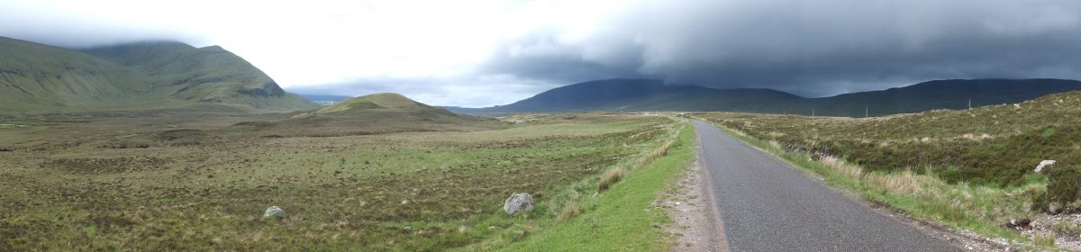
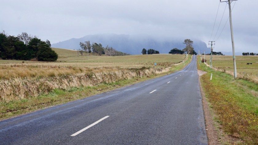
The 25 kilometer from my camp spot to Coles Bay were not the most pleasant due to the busy road and too many impatient drivers.
It’s Sunday, no time to waste, I guess.

First I headed to the Wineglass Bay Lookout.
After the national park visitor centre, the road has a few short steep inclinations.
It’s about 1,5 hour return walk to the lookout where one has to gain an elevation of about two hundred meter. As always, most of my fellow hikers were not in the best of shape and what keeps surprising me, bad equipped in the shoe department. People hike up in flip flops or the most fragile sandals.
A very high percentage of tourists in Australia is Chinese.
And the Chinese must worry.
They are in a much, much worse shape than the already sad state of my fellow western people.
They struggle and I heard some making noises I haven’t heard from humans before.
Smoke some more cigarettes, guys.
The view towards Wineglass Bay is world famous and rightfully so.
It was worth make the detour only for this.

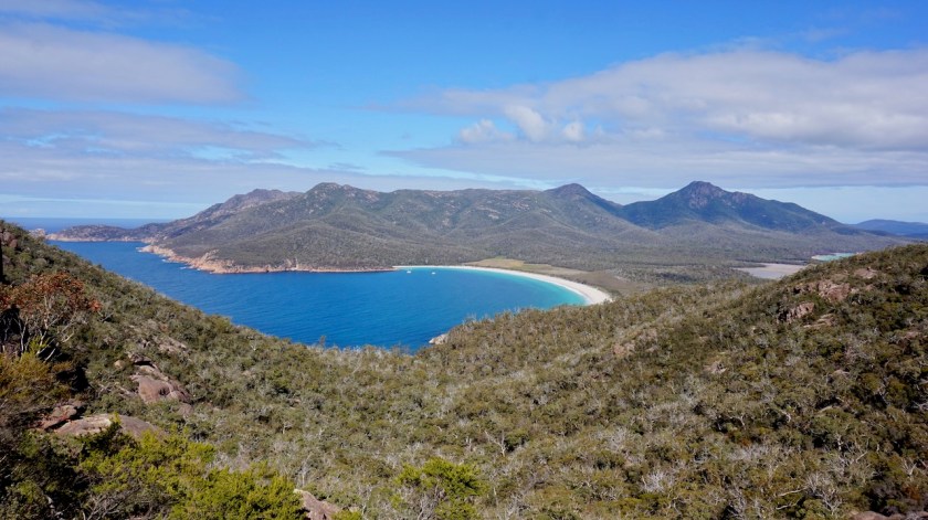
But, there’s more.
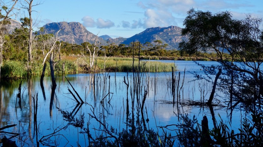
After hiking down, I went to Honeymoon Bay. Stunning scenery again, the crystal clear waters and the mountain peaks of ‘The Hazards’ behind that.
The four peaks, Mount Amos, Mount Dove, Mount Baudin and Mount Parsons can be climbed, but it is late afternoon and the weather will turn tomorrow.

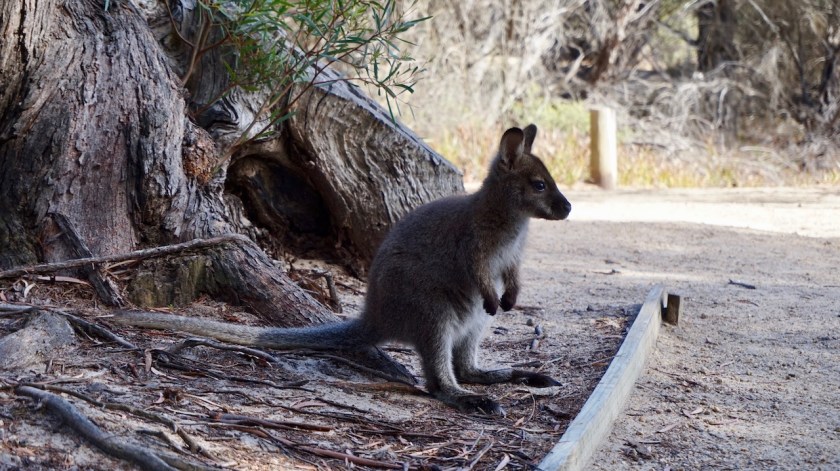
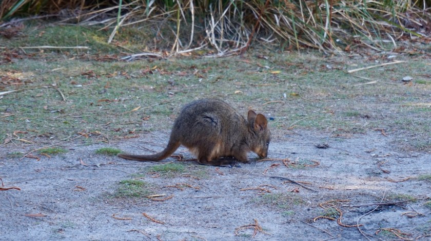
Returning to my bike from the bay, a Pademelon is sniffing my front panniers.He/she is not shy at all.
That means too many tourists.
I take the Cape Tourville Road towards Sleepy Bay, on the other side of the peninsula.
All worthwhile, all very impressive.
I don’t continue to the Cape Tourville lighthouse, as I really need to go shopping before closing time.
I always carry too much food, but that’s all eaten the last days. The initial plan was to ride via Ross and Campbell town, which I skipped, so I was still surviving on food bought in Triabunna.

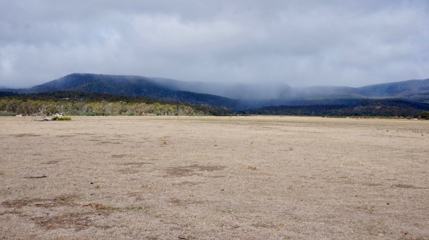
For a moment I hesitated to camp in the national park, along Richardsons Bay. It’s a very beautiful location. On my way back I rode along the side and more then half of them were taken, so that will be too loud.
I returned to no-mans-land a few kilometer outside Coles Bay and baked some burgers in front of my tent.
All good.
Day 39: 18 March 2019
From few km before Coles Bay to near Friendly Beaches
29,31 km (Total so far: 1500,76 km) – Altitude climbed: 213 m
Weather: Cloudy, light head wind
A lame day.
After breakfast I did some long overdue back-up’s of my pictures, then cycled back to Coles Bay to buy groceries for the next days.
In Swanwick, I found a public electricity connection and I had decent enough phone reception to make an update for the website whilst charging all my devices.
The plan to cycle all the way back out to the Tasman Highway and then back to Cranbrook where I will take a dirt road is out of the window for today; too late for that. Unless I could find a small boat that could bring me to the other side (Point Bagot) from where a track leads over the peninsula towards Swansea.
I cycled to the pier but there were no boats whatsoever, not even a small dinghy.
No worries, I’ve got food and water enough for an extra night out.
Friendly beaches looked pretty wild from the lookout at the top of the dunes. And pretty impressive. Untouched beaches, hopefully they will stay that way.
The national park has basic camping facilities down there (which they will upgrade), and I could see too many campervans for my liking, so I turned back, took another side track and found my own private place, with better wind protection for the night.
Day 40: 19 March 2019
From near Friendly Beaches to 7 km into Old Coach Road C301
35,38 km (Total so far: 1536,14 km) – Altitude climbed: 336 m
Weather: Cloudy, rain
The weather forecast for today was bad. On every website I consulted.
A few overnight showers, but dry when I woke up.
Packed the wet tent and I started cycling. If I would lose another day, I would have to ride to Bicheno for provisions, an additional 24 kilometer return trip on the Tasman highway.
The ride back to that Tasman Highway was no fun. Too many people in too much of a hurry giving too little space to cyclists, despite the frequent signs along the road to give minimum 1,5 meter.
Just after the junction, I went back into the ‘Pondering Frog Café’ for a coffee and a vegetable curry pie before taking on the fifteen kilometer on the Tasman Highway, which I dreaded.
Back over Cherry Tree Hill (185 meter), then coasting down towards the Old Coach Road where the joy could start again.
Miraculously, I saw rain showers all around me, but I kept it dry. The hills in front of me send a clear message. I saw the rain pouring down there, so pitched the tent at not the grandest of wild camping places after a short day in the saddle.
Good, because a couple of days ago, I purchased Peter Fitzsimons’ book ‘Burke & Wills’ on the Kindle. The cover shows an old picture of Australia’s most famous explorers. It’s a recent book (2018). 736 pages and after 75 pages I must say I love it.
And what a coincidence that, very roughly, the first part of my route on Australia’s mainland is not so different as what these men took. With the same aim, reaching the Gulf of Carpentaria, starting from Melbourne.
I still have to read 1/3 of Herman Brusselmans’ book ‘Hij Schreef te Weinig Boeken’ (639 pages) and am also reading Thomas Stevens’ ‘Around the World on a Bicycle – Volume I, From San Francisco to Teheran’, a 998 pages two volumes book about Thomas Stevens bike ride around the world started in …. 1884 !
That’s alternating between three different colossal works, but I love it.
Day 41: 20 March 2019
From 7 km into Old Coach Road to 1 km into Milford road
64,64 km (Total so far: 1600,78 km) – Altitude climbed: 667 m
Weather: Cloudy, sunny, strong tail wind
It hasn’t rained hard, but it did continuously until deep in the night which has made the Old Coach Road into sometimes a muddy affair. When I’m around 350 meter asl, I climb into the clouds.
descending from the Coggle Hills towards the settlement of Royal George, the sun reappears above the valley. While riding in the sun with a good tail wind through the St. Paul’s Plains, the Dickies Ridges to my right and the hills of Snow Hill Forest Reserve to my left, remain covered in clouds, a beautiful sight.
Near Royal George, the pavement started again. This is cycling at its best.
In Avoca I face a dilemma. I planned to go straight ahead here via the Storys Creek Road and a loop around Ben Lomond National Park.
But here too, nothing but thick, grey clouds and rain showers.
Or…. I could turn left, follow the Esk Highway in a westerly direction and continue riding in the sun.
I think it over while drinking a coke in the gas station and decide that riding those hills in that kind of weather would not bring me any fun.
So the highway it is.
Out of Avoca, a reasonable shoulder appears, traffic is light, the wind from the side now, it’s a good ride.
After Llewelyn, a one house settlement, I turn right into the Milford Road.
It says again ‘no through road’, but we’ll see tomorrow about that.
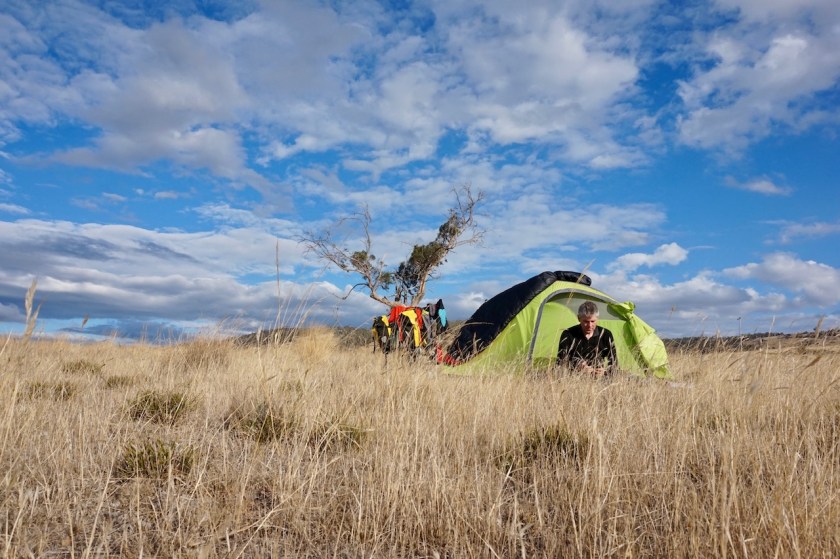
The land is unfenced, and although the wind blows still strong, I pitch the tent on the barren hill enjoying a wonderful, sunny evening. Even Ben Lomond shows its face later in the evening.
On the one side of my tent, I have the red sky of the sunset, while on the opposite side, a bright, gigantic full moon is rising from behind Ben Lomond.
Life indeed is very good again.
Day 42: 21 March 2019
From1 km into Milford Road to 1,5 km into road C521, Woolmers Road
71,61 km (Total so far: 1672,39 km) – Altitude climbed: 437 m
Weather: Sunny, light head wind, heavy rain in the night
Well, this is indeed a ‘no through road’.
Despite my map and my gps suggesting there’s a bridge here over the South Esk River, the track ended up at a private property. The owner said there was no bridge, which I think we can believe as the river is quite wide here and it seemed unlikely to me there would be a private bridge. Maybe google earth can tell more.
Anyways, I had to turn back, continued on the Esk Highway until the junction with the oh so busy Midland Highway, which I crossed, taking the small backroad towards Conara, thus avoiding the Highway. After Conara remains an 800 meter stretch on the highway before I can turn right on the Glen Esk Road (with a bridge over the South Esk River).
So, after cycling 30 kilometer, I was back at exactly 8 kilometer from where I started this morning.
No worries, the weather is fine, and so is the route.
The Nile Road which I’m following now is still partly gravel.
The amount of rotting road kill here is stunning. A death wallaby, possum, kangaroo always within sight, and definitely within smelling distance. Kilometer after kilometer this disgusting smell of rotting, death meat.
Every day, day after day, thousands and thousands of these animals must be killed on Australian roads and… nobody seems to give a f***.
Very bizar.
Very sad.

Evandale is a ‘historical town’.
A few buildings from the late 19th century, two churches, the St. Andrews Uniting Church and the St. Andrews Anglican Church.
More importantly, Evendale is every year the scene of the national Penny Farthing Cycling Championships, the last weekend of February.

Leaving town, one could pitch his tent in the park along the South Esk River, but I think it might be the scene of drinking and / or fishing men in the evening, so I pushed on finding a spot in a field, about 1,5 kilometer from the Midland Highway.
Dark grey clouds, terrible rain showers in the distance over Ben Lomond and over Evandale.
It eventually came my way and it rained until deep in the night.
Glad I’m not anywhere near en Lomond where it must have been much more serious. Good decision to skip it.

Day 43: 22 March 2019
From 1,5 km into road C521 to Along the Tasmanian Trail, off Mole Creek Road
81,22 km (Total so far: 1753,61 km) – Altitude climbed: 739 m
Weather: Sunny, cloudy, moderate head & side wind
To my surprise, and contrary to the weather predictions, I wake up to a blue sky. Still uncomfortable about the trespassing into this field, I pack my stuff and decide to have breakfast later on.
First I cross the Macquarie river again, which I still know from further upstream.
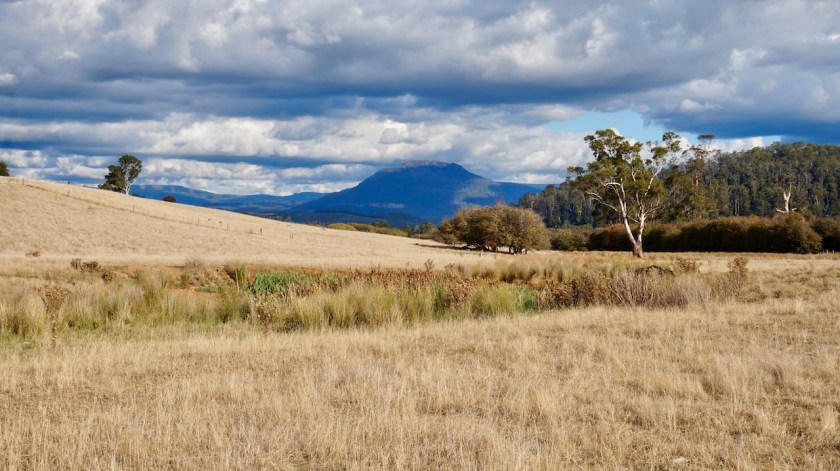
To my left, I have beautiful views to the Great Western Tiers and the Cluan Tiers, half covered in clouds.
In Longford, I stop in the beautiful park to eat something, and lay out the tent to dry completely.
Beautiful Church they have here.
The quiet backroads via Bracknell towards Deloraine are a joy to cycle and almost completely deserted of traffic. Richie Porte, Tasmania’s most famous cyclist, is from this region, I heard, so he must have been roaming this little roads as well.
Late afternoon, upon leaving Deloraine, the impressive Quamby Bluff (1226 m) shows its face.
I push on, out of town because a bit further I will rejoin the off-road Tasmanian Trail.
Instantly, I have to dismount and push the bike on an impossible incline, some 30% or more on rough stones.
I loaded the bike up with three days worth of food and eleven liter of water, because I want a rest day. Push with all my power, two steps up, brake to hold the bike, puf puf, regain my composure, two steps up, puf puf puf, brake…..
It’s an insane job, but better than the highway.
Soon, I find a place for the tent.
Day 44: 23 March 2019
From Along the Tasmanian Trail to TT, into the Gog Range, along Lobster Rivulet
5,52 km (Total so far: 1759,13) – Altitude climbed: 105 m
Weather: Cloudy, rain
Again a beautiful moonrise yesterday evening and an all dry night, so I could leave the tent fly unzipped and watch the stars. As the weather looked promising, I decided to ride a bit today and make the best of it, instead of taking a rest day.
Pushing ridiculously steep up again for a short stretch, then almost as steep down.
Just when I was crossing the Lobster Rivulet (no bridge), lightning and instantly a very loud thunder and it started raining.
A perfect place to pitch the tent a few meter above the river, so no hesitation. I pitched the tent and that was it for today, 5,52 km.
We’ll see tomorrow.
Day 45: 25 March 2019
From Along Lobster Rivulet to foot of Mount Roland
35,85 km (Total so far: 1794,98 km) – Altitude climbed: 942 m
Weather: Cloudy, rain, strong head wind
Easy going paths brought me to the borders of the Mersey River. It’s a wide stream here, no bridge. Impossible to bring the fully loaded bike over in one go. I offloaded everything and had to bring it all over in four times. So with going and coming back, I crossed the river seven times. Along the banks, the river was thigh high, but the water not too cold.
At the other side is a large flat piece of grass which would be ideal for camping.
However, this could be reached with 4WD, and seeing the remnants of big fires that have been built here, despite the many signs you shouldn’t do so, I don’t know whether this is always such a quiet place as today.
A steepish climb from the Mersey River back up, up to 12% but on good gravel roads, so all can be cycled.
All day, it looks like it could start raining, as the clouds pack together agains the Gog Mountain. The paths here are really heaven to ride and I don’t see another soul.
Further on, I see this whole track system is closed from this side.
Ideal 🙂

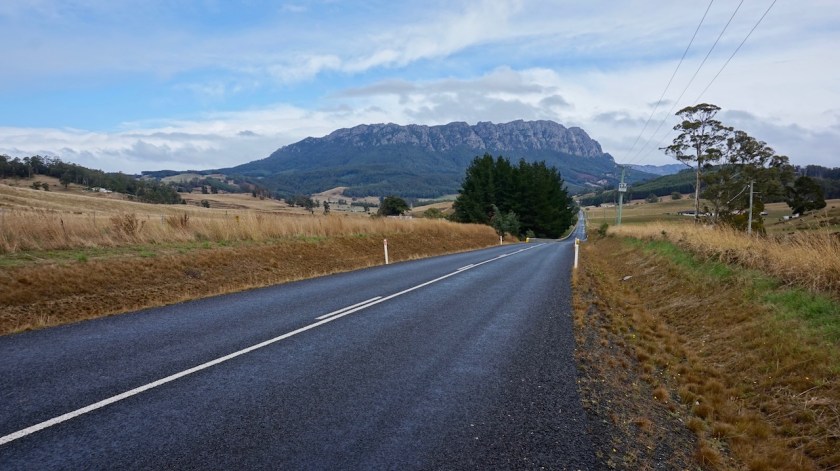
Back on the pavement follows a very steep climb on the Paradise Road. Normally, I would have views towards Mount Roland, but it’s all covered in clouds.
I decide to go to the start of one of the two tracks nevertheless and hope for better weather tomorrow to climb it.
Day 46: 25 March 2019
From foot of Mount Roland to along Sheffield to Railton Rail Trail
15,63 km (Total so far: 1810,61 km) – Altitude climbed: 674 m
Weather: Heavy rain, very strong tail & side wind
It has rained a lot all night again. After midnight, the wind picked up and became quite heavy, but I was well sheltered in the forest.
Between the showers, I could pack a half dry tent and pushed to bike to the beginning of the trail to Mount Roland. The wind was still very strong, making lots of noise in the trees.
The path climbs up pretty steep, and often you have to clamber over big rocks.
Upon approaching the tree line, it started to rain heavy. I took shelter under a death tree, but even with my rain jacket and a plastic poncho, you cool down quickly when not moving.
I checked the thermometer. 5.0 degrees C.
Waited some more, but the driving rain didn’t stop. Once out of the forest, in combination with the rain and the slippery rocks, this would only be a dangerous situation and I don’t want to jeopardize the rest of my trip by going to this top by all means.
I descended again, and even that proved to be a rather difficult task over the slippery boulders, needing my hands for support often.
Back half way down, the sun came out again.
I stopped. Should I continue going back, or give it another try. The sun was out now, and I won’t be back here all too soon.
Yes, I went back up.
And soon, the clouds were back, the wind picked up.
Ah, forget it, I go back down.
At the bike, the temperature was up to 8.1 degrees C.
On my way between Mount Roland and Sheffield (about 8 km), I had to get of the road and seek shelter once because the winds became so violent it blew me from the middle of the road back into to the side, the driving rain blinded me, then to mountain was covered in clouds again, back blue sky, back covered in clouds.
I’ve been to many places that claim to have four seasons in one day: Scotland, Iceland, Tierra del Fuego, …. but here, they have four seasons in fifteen minutes.
It was clear the mountain didn’t wan anybody up there today, so you better listen then.
I had lunch in Sheffield. Chinese, cashew nut chicken and curry beef with fried rice.
The sun was out when I mounted my bike, but 1,5 kilometer further, I was cycling back in the rain.
Pitched the tent along the rail trail to Railton, with some good wind shelter from the trees.
But it was cold, God…. so cold.
Temperatures dropped a lot today.
For the first time since arriving in Australia, I use the sleeping bag as a bag and not merely as a blanket. And in my bag, it was comfortably warm.

Day 47: 26 March 2019
From Along Sheffield to Railton Rail Trail to Devonport
30,85 km (Total so far: 1841,46 km) – Altitude climbed: 211 m
Weather: Cloudy, strong head and side wind
Continuing along the rail trail, I was surprised, and disappointed to see so much illegal dumping of garbage.
In Railton, I stopped at the place were Norman Sykes used to live.


The road from Railton to Latrobe is terrible with more than a few idiots on the road.
From Latrobe to Devonport, I took the River Road along the Mersey River, which was good.
I was again warmly welcomed in Hans and Claudia’s house in Devonport, where I stayed for two nights, having some interesting discussions about future plans with Hans.
Day 48: 27 March 2019
Devonport
Weather: Sunny
Today we drove with the car to Narawntapu National Park where we made a beautiful walk. There’s a lake with a wide variety of birds. The park is dubbed the Serengeti of Tasmania, I read later. And indeed, it feels as if you are watching a typical African safari landscape, although you are here, along the Bass Strait in the roaring 40’s.
We returned to the car via an almost deserted Baker Beach.
In Europe, there would be 50.000 people on this beach.
Day 49: 28 March 2019
Ferry from Devonport to Melbourne
Weather: Sunny
After spending another lovely, relaxing day, a haircut and a very good meal, I cycled to the ferry terminal to catch the Spirit of Tasmania. Again the nbr 1 (they’ve got 2).
Some figures about the Australia trip so far:
Total distance cycled on Tasmania: 1846,36 km
Average km per cycling day: 43,96 km
Total altimeter: 25.798 meter
Shortest cycling day: 5,52 km (Gog Range)
Longest cycling day: 81,22 km (northeast Tasmania)
Highest maximum speed: 69,75 km/hr (on Cradle Mountain Development Road)
Most altimeter in one day: 1167 m (towards Cradle Mountain)
Highest point: 959 m (on Cradle Mountain Development Road)
Longest day in the saddle: 6 hrs 23 minutes (Eastern Tears Forest Reserve, Tasmania)
Total time in the saddle: 142 hours 57 minutes
Nights slept inside: 4
Nights slept outside: 43 (of which 38 wild camping & 5 on campgrounds)
Flat tires: 0 (thank you Schwalbe for the Marathon Mondials !)
Other gear issues: punctured Therm-A-rest NeoAir
Number of road kill: estimated 20.000 (that’s if there would be on average only 1 dead animal every 100 meter)
Below, the map from my route on Tasmania, cycled anti-clockwise.
The gpx track can be downloaded from Wikiloc.
